


A team led by Prof. HONG Jin and Prof. YI Weining from Anhui Institute Of Optics and Fine Mechanics, Hefei Institutes of Physical Science (HFIPS), Chinese Academy of Sciences proposed an adaptive atmospheric correction algorithm for the effective adjacency effect correction of submeter-scale spatial resolution optical satellite images.
The relevant content was published on RSE (Remote Sensing of Environment).
For high spatial resolution imaging remote sensing, the atmospheric adjacency effect caused by ground-atmosphere cross radiation causes remote sensing image degradation and distortion of ground surface reflection information. On the sub-meter scale, the actual reflectance distribution of the ground surface is inhomogeneous and uniform, so it is difficult to accurately calculate the cross-radiation contribution of the adjacent area. For atmospheric adjacency effect correction of sub-meter resolution images, the core difficulty lies in the definition of the radiation contribution weight of each pixel in the adjacent background area. The traditional correction algorithm does not consider the non-uniformity of ground surface reflection.
According to the earth-atmosphere cross-radiation simulation analysis, the ratio of the background pixel reflectivity to the target pixel reflectivity has a correlation with the radiation contribution value of the adjacent area. Based on this correlation, the weight influence factor EABR (Equivalent Average Background Reflectance) that can characterize the ground surface inhomogeneity is set, and the weight function is modified and improved.
At the same time, considering the uncertainty of the actual contribution weight caused by the unknown distribution of the actual ground surface reflection, scientists introduced an iterative mechanism to calculate the weight value.
"Accurate data of the radiation contribution of the adjacent pixels can help us achieve atmospheric adjacency effect correction,” said CUI Wenyu, member of the team.
This result provides a method for atmospheric correction of high-resolution remote sensing images. On the other side, it is expected to remove the remote sensing imaging interference caused by the atmospheric variability of time and space effectively, and further improve remote sensing image data quality.
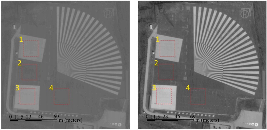
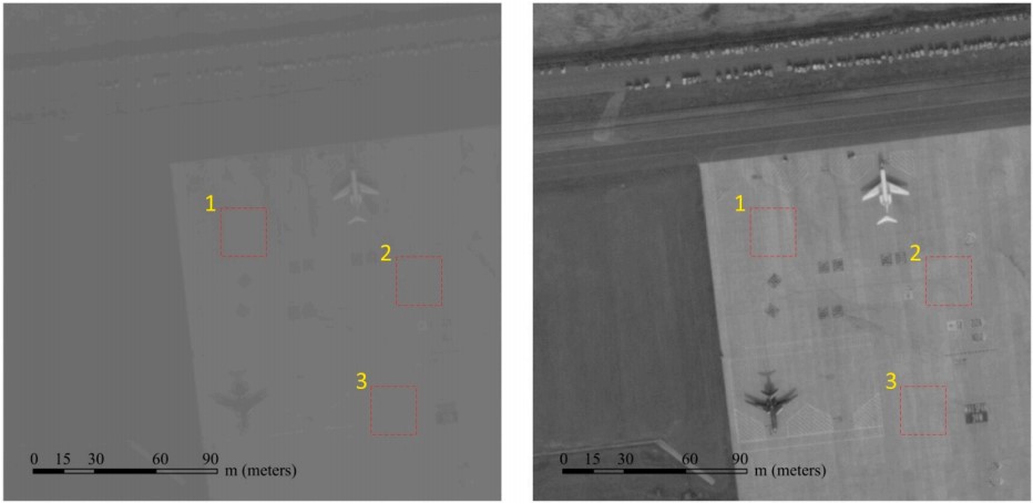
Comparison of correction effects. Apparent reflectance image(left) and satellite image corrected by adaptive-AC algorithm(right) (Image by CUI Wenyu)
Contact:
ZHAO Weiwei
Hefei Institutes of Physical Science (http://english.hf.cas.cn/)
Email: annyzhao@ipp.ac.cn