

A research group led by Prof. SUN Xiaobing from the Hefei Institutes of Physical Science of the Chinese Academy of Sciences, developed a method for accurately mapping paddy rice cultivation in Anhui Province. This method combined annual phenological features with Sentinel-1/2 imagery, leveraging satellite remote sensing and machine learning to enhance agricultural monitoring.
The findings were published in Agriculture.
Paddy rice is an important agricultural product. Accurate mapping of paddy rice fields is therefore essential for enhancing food security, promoting sustainable agriculture, increasing crop yields, and facilitating technological advancements that improve resource efficiency.
In this study, the researchers first derived annual phenological variations using verified ground truth data. They then assigned several vegetation indices to different phenological phases. Subsequently, pixel-level rice planting distribution maps were created using a machine learning process. To increase the sample size, the study implemented an automatic sample expansion technique, stratified across different grids within the study area.
The results of this method were validated using a confusion matrix, the Anhui Statistical Yearbook, and other rice mapping algorithms with similar resolutions. The proposed method demonstrated high accuracy in the primary grain-producing areas of Anhui and showed considerable practical value. Additionally, the sample expansion techniques developed in this study could be adapted for mapping other economically important crops. This research, which integrates phenological features with optical and SAR radar data for crop area estimation, has produced promising results.
"Our findings suggest that integrating phenology with remote sensing imagery and radar data could offer practical value for future agricultural planting and yield studies," said Prof. SUN Xiaobing.
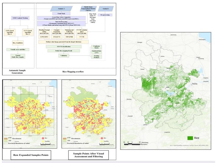
1 the flow chart of proposed study 2 sample expansion and visual verification 3 paddy rice distribution result in Anhui (Image by WANG Zeling)