A research team led by Prof. CHEN Cheng from Hefei Institutes of Physical Science, Chinese Academy of Sciences, has developed a method that can retrieve multiple aerosol properties from observations by two satellites without retraining.
The method has also been used to generate aerosol datasets covering land areas around the world, providing new data for tracking changes in atmospheric aerosols over time.
The study was recently published in Remote Sensing of Environment.
It uses observations from the Particulate Observing Scanning Polarimeter, a self-developed instrument carried aboard the GaoFen-5(02) (GF-5(02)) and DaQi-1 (DQ-1) satellites.
Atmospheric aerosols are tiny particles in the air, such as dust and smoke. They affect climate by scattering and absorbing sunlight. Satellite observations can help scientists determine how much aerosol is in the atmosphere, the size of the particles, and how strongly they absorb sunlight. However, accurately retrieving these properties from satellite measurements, particularly across different satellites, remains challenging.
To address this challenge, the team developed a method that combines satellite measurements with established physical relationships to retrieve several aerosol properties, including the amount of aerosol in the atmosphere, particle size, and light absorption. The researchers first developed the method using GF-5(02) observations and then applied it directly to DQ-1 data without additional training. Comparisons with ground-based measurements from the Aerosol Robotic Network (AERONET) showed good agreement for several aerosol properties, supporting the method's use across the two satellite platforms.
Using this method, the team has generated aerosol datasets for land areas around the world, including products from each satellite and a combined dataset based on observations from both. The datasets help fill a gap in satellite observations of atmospheric aerosols and complement data from newer satellite missions. The processing system continues to be updated as new observations become available.
"This method allows us to combine observations from different satellites, helping us track long-term changes in aerosols, understand their effects on climate, and compare data across satellite missions, said Prof. CHEN.
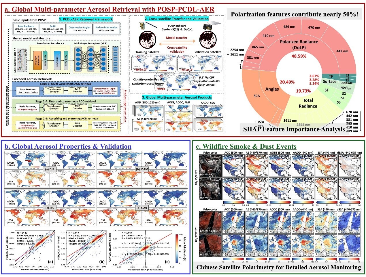
Polarimetric remote sensing from Chinese satellites enables detailed characterization of global aerosol properties. (Image by CHEN Cheng)