A research team led by Prof. ZHU Hui at the Institute of Intelligent Machines, Hefei Institutes of Physical Science, Chinese Academy of Sciences, have developed two methods to improve enhance reconstruction fidelity, helping robots build more accurate representations of their surroundings. One method combines LiDAR and camera data to reconstruct complex driving scenes, while the other uses geometric features to improve localization and mapping.
Both studies have been accepted for presentation at the 2026 IEEE International Conference on Robotics and Automation (ICRA 2026). The paper on scene reconstruction was also selected as the Best Paper Award Finalist in the robot perception, one of only three papers to receive this distinction among more than 5,000 submissions.
Accurately scene reconstruction is important for robots to understand their surroundings, but challenges remain in handling moving objects, changing lighting conditions and complex geometric structures.
To address these challenges, the team developed LR-SGS, a method for high-quality 3D scene reconstruction, and MMD-SLAM, a method that improves robot positioning and 3D mapping.
LR-SGS combines LiDAR data with camera images to improve the reconstruction of driving scenes. By using the intensity, it captures scene details under different lighting conditions, including at night. It also identifies key structural features while suppressing redundant information, thereby improving reconstruction efficiency. Experiments on datasets such as Waymo showed that LR-SGS improves reconstruction accuracy and training efficiency while maintaining a compact 3D representation. Furthermore, the reconstructed scenes are editable and can be used to create virtual driving environments for autonomous driving simulation and testing.
MMD-SLAM, meanwhile, improves how robots track their positions and map their surroundings. It makes use of geometric features such as points, lines and planes in buildings and other man-made environments. By combining these features, the method produces more consistent 3D maps and improves positioning accuracy. Tests on multiple datasets showed better mapping and tracking performance while maintaining real-time processing efficiency.
Meanwhile, MMD-SLAM improves robot tracking and mapping accuracy. The method exploits geometric features, including points, lines, and planes, commonly found in environments. By integrating these geometric cues, MMD-SLAM enhances point cloud map consistency and improves localization accuracy. Experiments on multiple datasets demonstrate that the method achieves superior tracking and mapping performance while maintaining real-time efficiency.
The two methods provide new tools for scene reconstruction, with potential applications in robotics and intelligent systems.
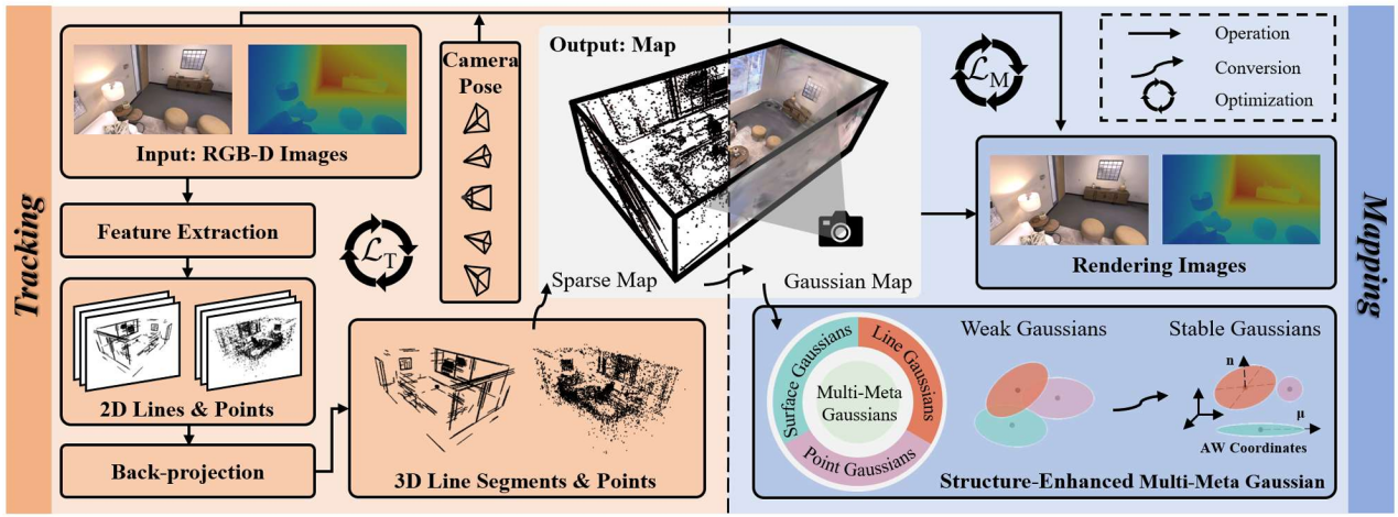
MMD-SLAM Architecture (Image by JIANG Chunmao)
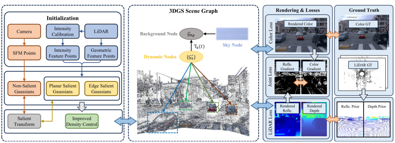
LR-SGS Architecture (Image by JIANG Chunmao)